Use coupon code “WINTER20” for a 20% discount on all items! Valid until 30-11-2024

Site Logo
Search Suggestions

      Royal Mail  express delivery to UK destinations

      Regular sales and promotions

      Stock updates every 20 minutes!

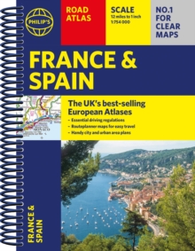
      Philip’s France and Spain Road Atlas: A4 Spiral

      52 in stock

      Firm sale: non returnable item
      SKU 9781849076302 Categories ,
      Select Guide Rating
      The Philip's France and Spain Road Atlas, in a handy spiral A4 format, is the must-have atlas for anyone travelling around these countries.

      The latest edition of Philip''s France and Spain Road Atlas, in a handy spiral A4 format, is the must-have atlas for an...

      £12.99

      Buy new:

      Delivery: UK delivery Only. Usually dispatched in 1-2 working days.

      Shipping costs: All shipping costs calculated in the cart or during the checkout process.

      Standard service (normally 2-3 working days): 48hr Tracked service.

      Premium service (next working day): 24hr Tracked service – signature service included.

      Royal mail: 24 & 48hr Tracked: Trackable items weighing up to 20kg are tracked to door and are inclusive of text and email with ‘Leave in Safe Place’ options, but are non-signature services. Examples of service expected: Standard 48hr service – if ordered before 3pm on Thursday then expected delivery would be on Saturday. If Premium 24hr service used, then expected delivery would be Friday.

      Signature Service: This service is only available for tracked items.

      Leave in Safe Place: This option is available at no additional charge for tracked services.
      Description

      Product ID:9781849076302
      Product Form:Spiral bound
      Country of Manufacture:GB
      Series:Philip's Road Atlases
      Title:Philip's France and Spain Road Atlas
      Subtitle:A4 Spiral
      Authors:Author: Philip's Maps
      Page Count:88
      Subjects:Road atlases and maps, Road atlases & maps, France, Spain
      Description:Select Guide Rating
      The Philip's France and Spain Road Atlas, in a handy spiral A4 format, is the must-have atlas for anyone travelling around these countries.

      The latest edition of Philip''s France and Spain Road Atlas, in a handy spiral A4 format, is the must-have atlas for anyone travelling or driving in these and the adjacent countries including Belgium, Luxembourg and Portugal.

      From the market leaders in European Road Mapping, in addition to the main maps at 1:750,000, the road network is shown at three supplementary scales from 1:250,000 to 1:3M, with ultra-clear detailed maps for urban areas, so that you can navigate in this part of Europe with ease.

      Scenic routes are highlighted on the road maps, with theme parks and World Heritage Sites also clearly shown. The maps highlight towns with low-emission zones and show motorway rest/parking areas, not forgetting handy listings of top sites to visit and useful ski resort information.

      Philip''s France and Spain Road Atlas includes:

      * Up-to-date driving regulations, including speed limits;
      * 4 pages of route-planning maps which enable journeys of over 800 miles to be planned without turning a page;
      * 57 pages of clear, detailed road maps, with scenic routes highlighted and toll, toll-free and pre-pay motorways all clearly marked;
      * 6 large-scale urban-area maps;
      * 11 city-centre plans marking historic buildings and tourist attractions, as well as car parks, head post offices and other facilities;
      * Listings for ski resorts and top visitor attractions.


      Imprint Name:Philip's
      Publisher Name:Octopus Publishing Group
      Country of Publication:GB
      Publishing Date:2023-01-05

      Additional information

      Weight264 g
      Dimensions218 × 298 × 13 mm