Use coupon code “WINTER20” for a 20% discount on all items! Valid until 30-11-2024

Site Logo
Search Suggestions

      Royal Mail  express delivery to UK destinations

      Regular sales and promotions

      Stock updates every 20 minutes!

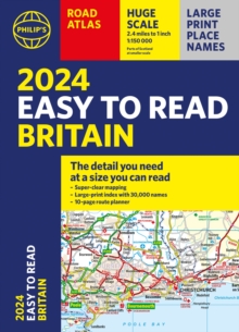
      2024 Philip’s Easy to Read Britain Road Atlas: (A4 Paperback)

      16 in stock

      Firm sale: non returnable item
      SKU 9781849076203 Categories ,
      Select Guide Rating
      "The detail you need at a size you can read". The latest 2024 Easy to Read Britain Road Atlas from Philip's Road Atlas range. A practical and chunky A4-sized paperback with handy flaps to help plan any journey. - Large print maps- Huge 1:150,000 scale (approx 2.4 miles to 1 ...

      £15.99

      Buy new:

      Delivery: UK delivery Only. Usually dispatched in 1-2 working days.

      Shipping costs: All shipping costs calculated in the cart or during the checkout process.

      Standard service (normally 2-3 working days): 48hr Tracked service.

      Premium service (next working day): 24hr Tracked service – signature service included.

      Royal mail: 24 & 48hr Tracked: Trackable items weighing up to 20kg are tracked to door and are inclusive of text and email with ‘Leave in Safe Place’ options, but are non-signature services. Examples of service expected: Standard 48hr service – if ordered before 3pm on Thursday then expected delivery would be on Saturday. If Premium 24hr service used, then expected delivery would be Friday.

      Signature Service: This service is only available for tracked items.

      Leave in Safe Place: This option is available at no additional charge for tracked services.

      Description

      Product ID:9781849076203
      Product Form:Paperback / softback
      Country of Manufacture:GB
      Series:Philip's Road Atlases
      Title:2024 Philip's Easy to Read Britain Road Atlas
      Subtitle:(A4 Paperback)
      Authors:Author: Philip's Maps
      Page Count:352
      Subjects:Earth Sciences, Geography, Environment, Planning, Earth sciences, geography, environment, planning, Travel maps and atlases, Road atlases and maps, Travel maps, Street maps and city plans, Travel maps & atlases, Road atlases & maps, Travel maps, Street maps & city plans, United Kingdom, Great Britain
      Description:Select Guide Rating
      "The detail you need at a size you can read". The latest 2024 Easy to Read Britain Road Atlas from Philip's Road Atlas range. A practical and chunky A4-sized paperback with handy flaps to help plan any journey. - Large print maps- Huge 1:150,000 scale (approx 2.4 miles to 1 inch)- Large print place names- Large print index- Super-clear 10-page routeplanner- Handy flaps to mark pages and keep track of journeysAt last, a Road Atlas that everyone can read easily, in or out of the car, no matter what the conditions. Large scale maps, large print place names, clear road colours (which are easier to read in the dark), a large print index and a special route-planning section that's almost a road atlas in itself. With a distance chart for quick calculations, thousands of attractions and hundreds of campsites clearly marked, packed with clearly outlined scenic routes and viewpoints, and all counties marked up, your travels have never been easier to plan. If it's dark, or you just can't find your glasses, the new Philip's Easy to Read Britain Road Atlas is the answer - wherever you're driving in England, Scotland or Wales.

      "The detail you need at a size you can read". The latest 2024 Easy to Read Britain Road Atlas from Philip''s Road Atlas range. A practical and chunky A4-sized paperback with handy flaps to help plan any journey.

      - Large print maps
      - Huge 1:150,000 scale (approx 2.4 miles to 1 inch)
      - Large print place names
      - Large print index
      - Super-clear 10-page routeplanner
      - Handy flaps to mark pages and keep track of journeys

      At last, a Road Atlas that everyone can read easily, in or out of the car, no matter what the conditions. Large scale maps, large print place names, clear road colours (which are easier to read in the dark), a large print index and a special route-planning section that''s almost a road atlas in itself.

      With a distance chart for quick calculations, thousands of attractions and hundreds of campsites clearly marked, packed with clearly outlined scenic routes and viewpoints, and all counties marked up, your travels have never been easier to plan.

      If it''s dark, or you just can''t find your glasses, the new Philip''s Easy to Read Britain Road Atlas is the answer - wherever you''re driving in England, Scotland or Wales.


      Imprint Name:Philip's
      Publisher Name:Octopus Publishing Group
      Country of Publication:GB
      Publishing Date:2023-04-06

      Additional information

      Weight936 g
      Dimensions215 × 298 × 16 mm