Use coupon code “WINTER20” for a 20% discount on all items! Valid until 30-11-2024

Site Logo
Search Suggestions

      Royal Mail  express delivery to UK destinations

      Regular sales and promotions

      Stock updates every 20 minutes!

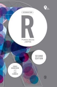
      An Introduction to R for Spatial Analysis and Mapping

      1 in stock

      Firm sale: non returnable item
      SKU 9781526428509 Categories ,
      Select Guide Rating
      This is a new edition of the accessible and student-friendly 'how to' for anyone using R for the first time, for use in spatial statistical analysis, geocomputation and digital mapping.

      This is a new edition of the accessible and student-frien...

      £44.99

      Buy new:

      Delivery: UK delivery Only. Usually dispatched in 1-2 working days.

      Shipping costs: All shipping costs calculated in the cart or during the checkout process.

      Standard service (normally 2-3 working days): 48hr Tracked service.

      Premium service (next working day): 24hr Tracked service – signature service included.

      Royal mail: 24 & 48hr Tracked: Trackable items weighing up to 20kg are tracked to door and are inclusive of text and email with ‘Leave in Safe Place’ options, but are non-signature services. Examples of service expected: Standard 48hr service – if ordered before 3pm on Thursday then expected delivery would be on Saturday. If Premium 24hr service used, then expected delivery would be Friday.

      Signature Service: This service is only available for tracked items.

      Leave in Safe Place: This option is available at no additional charge for tracked services.

      Description

      Product ID:9781526428509
      Product Form:Paperback / softback
      Country of Manufacture:GB
      Series:Spatial Analytics and GIS
      Title:An Introduction to R for Spatial Analysis and Mapping
      Authors:Author: Chris Brunsdon, Lex Comber
      Page Count:336
      Subjects:Social research and statistics, Social research & statistics, Mathematical and statistical software, Mathematical & statistical software
      Description:Select Guide Rating
      This is a new edition of the accessible and student-friendly 'how to' for anyone using R for the first time, for use in spatial statistical analysis, geocomputation and digital mapping.

      This is a new edition of the accessible and student-friendly ''how to'' for anyone using R for the first time, for use in spatial statistical analysis, geocomputation and digital mapping. The authors, once again, take readers from ‘zero to hero’, updating the now standard text to further enable practical R applications in GIS, spatial analyses, spatial statistics, web-scraping and more.


      Revised and updated, each chapter includes:

      • example data and commands to explore hands-on;
      • scripts and coding to exemplify specific functionality;
      • self-contained exercises for students to work through;
      • embedded code within the descriptive text.


      The new edition includes detailed discussion of new and emerging packages within R like sf, ggplot, tmap, making it the go to introduction for all researchers collecting and using data with location attached. This is the introduction to the use of R for spatial statistical analysis, geocomputation, and GIS for all researchers - regardless of discipline - collecting and using data with location attached.


      Imprint Name:Sage Publications Ltd
      Publisher Name:Sage Publications Ltd
      Country of Publication:GB
      Publishing Date:2018-12-24

      Additional information

      Weight648 g
      Dimensions172 × 242 × 15 mm