Use coupon code “WINTER20” for a 20% discount on all items! Valid until 30-11-2024

Site Logo
Search Suggestions

      Royal Mail  express delivery to UK destinations

      Regular sales and promotions

      Stock updates every 20 minutes!

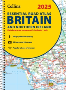
      2025 Collins Essential Road Atlas Britain and Northern Ireland: A4 Spiral

      26 in stock

      Firm sale: non returnable item
      SKU 9780008652906 Categories ,
      Select Guide Rating
      Explore Britain with easy-to-read mapping from Collins.
      Explore Britain with easy-to-read mapping from Collins.This A4, spiral-bound road atlas provides clear and detailed road mapping for England, Wales and Southern Scotland at a scale of 3.2 miles to 1 inch (1:200,000). F...

      £14.99

      Buy new:

      Delivery: UK delivery Only. Usually dispatched in 1-2 working days.

      Shipping costs: All shipping costs calculated in the cart or during the checkout process.

      Standard service (normally 2-3 working days): 48hr Tracked service.

      Premium service (next working day): 24hr Tracked service – signature service included.

      Royal mail: 24 & 48hr Tracked: Trackable items weighing up to 20kg are tracked to door and are inclusive of text and email with ‘Leave in Safe Place’ options, but are non-signature services. Examples of service expected: Standard 48hr service – if ordered before 3pm on Thursday then expected delivery would be on Saturday. If Premium 24hr service used, then expected delivery would be Friday.

      Signature Service: This service is only available for tracked items.

      Leave in Safe Place: This option is available at no additional charge for tracked services.
      Description

      Product ID:9780008652906
      Product Form:Spiral bound
      Country of Manufacture:GB
      Series:Collins Road Atlas
      Title:2025 Collins Essential Road Atlas Britain and Northern Ireland
      Subtitle:A4 Spiral
      Authors:Author: Collins Maps
      Page Count:344
      Subjects:World / regional atlases or maps, World atlases / world maps, Travel and holiday guides, Road atlases and maps, Travel & holiday guides, Road atlases & maps, United Kingdom, Great Britain
      Description:Select Guide Rating
      Explore Britain with easy-to-read mapping from Collins.
      Explore Britain with easy-to-read mapping from Collins.This A4, spiral-bound road atlas provides clear and detailed road mapping for England, Wales and Southern Scotland at a scale of 3.2 miles to 1 inch (1:200,000). For Northern Scotland the mapping is at a scale of 4.2 miles to 1 inch (1:266,000), with land height shown by different layers of colouring.Main features:Route planning section including maps at a scale of 22 miles to 1 inch, motorway services information, and a handy distance calculator chartMore than 20 urban approach maps at a larger scale which clearly show the best routes through and into built-up areas64 street maps focused on town centres showing places of interest, car park locations and one-way streets. All the street maps are fully indexedOver 30 categories of places of interest including castles, theme parks, sports venues, universities, mountain bike trails and surfing beachesThe top 1000 most visited places of interest are indexed with full postcodes to aid integration with sat-nav systemsUpdated Park & Ride locations, new rail stations and extensions to tram lines in Blackpool and EdinburghThis is the ideal purchase for drivers, navigators and route planners who want the very best road atlas of Britain in an A4 format.
      Imprint Name:Collins
      Publisher Name:HarperCollins Publishers
      Country of Publication:GB
      Publishing Date:2024-03-28

      Additional information

      Weight1020 g
      Dimensions304 × 230 × 25 mm