Use coupon code “WINTER20” for a 20% discount on all items! Valid until 30-11-2024

Site Logo
Search Suggestions

      Royal Mail  express delivery to UK destinations

      Regular sales and promotions

      Stock updates every 20 minutes!

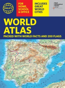
      Philip’s RGS World Atlas (A4): with Global Cities, Facts and Flags

      149 in stock

      Firm sale: non returnable item
      SKU 9781849075916 Categories ,
      Select Guide Rating
      Thousands of global facts at your fingertips with the best value quick-reference World Atlas on the market. Both physical and political geography is clearly illustrated alongside the great cities of our planet.

      Thousands of global facts at your fingertips with the be...

      £5.99

      Buy new:

      Delivery: UK delivery Only. Usually dispatched in 1-2 working days.

      Shipping costs: All shipping costs calculated in the cart or during the checkout process.

      Standard service (normally 2-3 working days): 48hr Tracked service.

      Premium service (next working day): 24hr Tracked service – signature service included.

      Royal mail: 24 & 48hr Tracked: Trackable items weighing up to 20kg are tracked to door and are inclusive of text and email with ‘Leave in Safe Place’ options, but are non-signature services. Examples of service expected: Standard 48hr service – if ordered before 3pm on Thursday then expected delivery would be on Saturday. If Premium 24hr service used, then expected delivery would be Friday.

      Signature Service: This service is only available for tracked items.

      Leave in Safe Place: This option is available at no additional charge for tracked services.

      Description

      Product ID:9781849075916
      Product Form:Paperback / softback
      Country of Manufacture:CN
      Series:Philip's World Atlas
      Title:Philip's RGS World Atlas (A4)
      Subtitle:with Global Cities, Facts and Flags
      Authors:Author: Philip's Maps
      Page Count:64
      Subjects:World / regional atlases or maps, World atlases / world maps, Historical maps and atlases, Cartography, map-making and projections, Historical maps & atlases, Cartography, map-making & projections
      Description:Select Guide Rating
      Thousands of global facts at your fingertips with the best value quick-reference World Atlas on the market. Both physical and political geography is clearly illustrated alongside the great cities of our planet.

      Thousands of global facts at your fingertips with the best value quick-reference World Atlas on the market. Both physical and political geography is clearly illustrated alongside the great cities of our planet.

      The highest peak? The deepest ocean trench? The wettest, driest, longest, largest - we list the world''s fascinating extremes. Crammed with practical information like a Distance Chart for World Cities, World Time Zones, over 200 State Flags and the top 100 most populous countries, we include around 15,000 places indexed for easy checking. Whether for the pub quiz, travel planning or school reference, this great value handy world atlas is crammed with everything you need to know.

      Alongside the topography and physical attributes of the earth we also show political boundaries and the great global cities, including transport hubs and places of interest from mosques to temples, palaces to zoos and shopping centres to tourist information centres.

      Features include:
      * 200 Flags of the world''s major states and territories
      * 21 City centre maps: transport (road, rail, trams, light railways, bus and railway stations) and places of interest including religious buildings (churches, abbeys, cathedrals, synagogues, shrines, temples, mosques), museums, galleries, theatres, palaces, castles, parks, gardens, zoos, shopping centres, hospitals, Tourist Centres.
      * World city distance table
      * World time zones map
      * World country comparisons table - the population and areas of the world''s top 100 most populous countries
      * World physical comparisons- largest oceans, longest rivers, biggest islands, highest peaks, deepest trenches.
      * Continental Comparator - for each one we show area, coldest place, hottest place, wettest place, driest place
      * World topographic maps - with coloured contour layers and hill-shading clearly outlining the Earth''s surface.
      * World political maps - the latest boundary and geopolitical changes, with cities, provinces and countries shown.
      * Index of around 15,000 place-names - with geographical features like mountains, lakes and deserts, as well as towns.


      Imprint Name:Philip's
      Publisher Name:Octopus Publishing Group
      Country of Publication:GB
      Publishing Date:2022-03-03

      Additional information

      Weight340 g
      Dimensions309 × 230 × 7 mm