Use coupon code “WINTER20” for a 20% discount on all items! Valid until 30-11-2024

Site Logo
Search Suggestions

      Royal Mail  express delivery to UK destinations

      Regular sales and promotions

      Stock updates every 20 minutes!

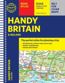
      Philip’s Handy Road Atlas Britain: (Spiral A5)

      6 in stock

      Firm sale: non returnable item
      SKU 9781849075770 Categories ,
      Select Guide Rating
      The essential handy road atlas for planning a trip in Britain and Ireland. Keep it in the glove box or your travel bag for quick and easy reference.

      "The perfect atlas for planning a trip anywhere in the UK and Ireland"

      The essential handy road atlas f...

      £5.99

      Buy new:

      Delivery: UK delivery Only. Usually dispatched in 1-2 working days.

      Shipping costs: All shipping costs calculated in the cart or during the checkout process.

      Standard service (normally 2-3 working days): 48hr Tracked service.

      Premium service (next working day): 24hr Tracked service – signature service included.

      Royal mail: 24 & 48hr Tracked: Trackable items weighing up to 20kg are tracked to door and are inclusive of text and email with ‘Leave in Safe Place’ options, but are non-signature services. Examples of service expected: Standard 48hr service – if ordered before 3pm on Thursday then expected delivery would be on Saturday. If Premium 24hr service used, then expected delivery would be Friday.

      Signature Service: This service is only available for tracked items.

      Leave in Safe Place: This option is available at no additional charge for tracked services.

      Description

      Product ID:9781849075770
      Product Form:Spiral bound
      Country of Manufacture:CN
      Series:Philip's Road Atlases
      Title:Philip's Handy Road Atlas Britain
      Subtitle:(Spiral A5)
      Authors:Author: Philip's Maps
      Page Count:80
      Subjects:Road atlases and maps, Road atlases & maps, United Kingdom, Great Britain
      Description:Select Guide Rating
      The essential handy road atlas for planning a trip in Britain and Ireland. Keep it in the glove box or your travel bag for quick and easy reference.

      "The perfect atlas for planning a trip anywhere in the UK and Ireland"

      The essential handy road atlas for planning a trip in Britain and Ireland. Keep it in the glove box or
      your travel bag for quick and easy reference.

      This gem of a glove-box sized atlas has all the core information you need for driving around the British Isles. It includes all the motorways, primary roads and A Roads and they are clearly shown - ideal for route planning. There is a separate 4-page road map of Ireland for easy use. Alongside that, this handy atlas includes a key map, a distance table and useful counties map.

      All the towns and villages listed within are indexed and all the information comes in a handy glove-box size format with practical, lie-flat spiral binding. With the scale at a user-friendly 8 miles to 1 inch / 1:500,000 (Ireland 19 miles to 1 inch /1:1,200,000) and fully up-to-date using Philip''s clear mapping, you will never be at a loss to establish the best route.

      Keep in the car or sling in your bag before travelling, the Philip''s Handy Road Atlas of Britain is also great value at only £5.99.


      Imprint Name:Philip's
      Publisher Name:Octopus Publishing Group
      Country of Publication:GB
      Publishing Date:2021-10-14

      Additional information

      Weight142 g
      Dimensions163 × 212 × 12 mm