Use coupon code “SUMMER20” for a 20% discount on all items! Valid until 2024-08-31

Site Logo
Search Suggestions

      Royal Mail  express delivery to UK destinations

      Regular sales and promotions

      Stock updates every 20 minutes!

      Philip’s Caribbean Atlas for Secondary Schools: 8th Edition

      1 in stock

      Firm sale: non returnable item
      SKU 9781849076470 Categories ,
      Select Guide Rating
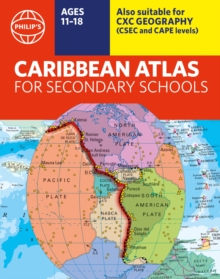
      Created specially for CXC Geography students in secondary schools and colleges, this market-leading atlas provides extensive, up-to-date coverage for each country in the Caribbean region, combined with a comprehensive set of world and regional maps.

      A new edition of the ...

      £13.00

      Buy new:

      Delivery: UK delivery Only. Usually dispatched in 1-2 working days.

      Shipping costs: All shipping costs calculated in the cart or during the checkout process.

      Standard service (normally 2-3 working days): 48hr Tracked service.

      Premium service (next working day): 24hr Tracked service – signature service included.

      Royal mail: 24 & 48hr Tracked: Trackable items weighing up to 20kg are tracked to door and are inclusive of text and email with ‘Leave in Safe Place’ options, but are non-signature services. Examples of service expected: Standard 48hr service – if ordered before 3pm on Thursday then expected delivery would be on Saturday. If Premium 24hr service used, then expected delivery would be Friday.

      Signature Service: This service is only available for tracked items.

      Leave in Safe Place: This option is available at no additional charge for tracked services.

      Description

      Product ID:9781849076470
      Product Form:Paperback / softback
      Country of Manufacture:GB
      Series:Philip's World Atlas
      Title:Philip's Caribbean Atlas for Secondary Schools
      Subtitle:8th Edition
      Authors:Author: Philip's Maps
      Page Count:184
      Subjects:Educational: Geography, Educational: Geography, Children’s / Teenage reference: Atlases and maps, Atlases & maps (Children’s/Teenage)
      Description:Select Guide Rating
      Created specially for CXC Geography students in secondary schools and colleges, this market-leading atlas provides extensive, up-to-date coverage for each country in the Caribbean region, combined with a comprehensive set of world and regional maps.

      A new edition of the market-leading atlas for CXC Geography students, Philip''s Caribbean Atlas for Secondary Schools provides extensive coverage of the Caribbean area, together with a comprehensive selection of world and regional maps.

      The atlas is arranged in three sections for ease of use, with each page colour-coded for rapid reference. The first section is devoted to a detailed coverage of the Caribbean region in 48 pages, and includes maps of every island plus Belize and Guyana, as well as topographical, land use, tourism and mining maps.

      The second section is made up of 72 pages of World topographical maps, incorporating continental thematic maps on topics such as population, climate and biomes, followed by 32 pages of World thematic maps. This new 8th edition features updated mapping of all Caribbean islands, as well as the latest statistics. The World map section contains additional coverage of Brazil, the Americas and Asia, while the World thematic section includes maps on volcanoes, El Niño, tourism, energy, minerals, industry, trade and international organizations.

      Completing the atlas is a section of CXC study maps covering topics such as farming, soil conservation, economics, tourism and urban land use. Features regional studies of Mauritius, UK, Canada, USA and Brazil.

      The index gives letter-figure grid references as well as latitude and longitude co-ordinates.


      Imprint Name:Philip's
      Publisher Name:Octopus Publishing Group
      Country of Publication:GB
      Publishing Date:2023-05-04

      Additional information

      Weight722 g
      Dimensions225 × 286 × 14 mm